

Maps
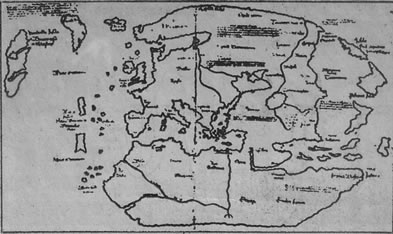
![[ Stefánsson map, c.1590 ]](../../images/site/163721_2.jpg "[ Stefánsson map, c.1590 ]")
Stefánsson map, c.1590, The map shows Greenland as part of the polar mainland and Helluland, Markland and Skrælingeland south and west of Greenland. Separated from the latter by a narrow strait is a long narrow peninsula called in Latin Promontorium Vinlandiæ, the Promontory of Vinland. The peninsula is more or less on the same latitudes as England and Ireland., Sigurd Stefánsson, Manuscript Department, Royal Library, Copenhagen
Three maps are part of the Vinland mystery. It is not certain that their information can be trusted in spite the fact that they all show the location of Vinland
The first map was made around 1590 by the Icelander Sigurdur Stefansson. After studying at the University of Copenhagen, Sigurdur became a teacher at the former monastery of Skálholt, which remained the religious and educational centre in Iceland even after Protestantism was introduced in 1551. Sigurdur himself was the grandson of a Skálholt bishop. Unfortunately Sigurdur’s tenure became short: he drowned in 1594 at the age of twenty-five.
The map shows a long narrow peninsula called Promontorium Winlandiæ extending towards the north, lying south of Markland and Helluland and opposite Skrælingeland. Sigurdur’s original map has been lost. What survives is a copy made in 1690 for Thordur Thorlaksson, also known by his Latinized name, Thorlacius, another Bishop of Skálholt. Thordur added comments in the margin. The map is in the collections of the Danish Royal Library.
The second map was made in September 1605 by a Dane, Hans Poulsen Resen. Resen had a vivid interest for Iceland and its ancient history. Resen first served as professor at the University of Copenhagen and later Bishop of Zealand [the large island on which Copenhagen is located]. His map was made shortly after a Danish expedition to Greenland in the summer of 1605 to search for the Norse settlements there. This map also shows Vinland as a long narrow peninsula extending north.
Resen stated that his map was based on ancient sources. Later scholars have pointed out that such claims were commonly made to validate work. It is clear, however, that Resen has incorporated information gained from the voyages of Martin Frobisher, 1576 to 1578, and those of John Davis in 1585 to 1587. The Resen map also has extensive comments in the margins.
The Resen map is in the collections of the Danish Royal Library. The original is so fragile that it could not be properly photographed the first time it was published in 1886, so a meticulous copy was made.
The third map is called the Vinland map. It shows a large island named Vinlanda insula [Vinland Island] west of Greenland. Its maker is unknown. The existence of the map was made public in 1965 at which time it was bound together with a medieval travel account called the Tartar Relation, dated to about 1340. The map is considered fraudulent by many while others believe it to be a true medieval document. The controversy has focussed on the type of ink used, a Latin text on the map, and the manner in which it was obtained and later sold to Yale University in whose possession it remains.
Maps