Maps
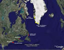
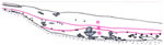
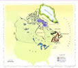
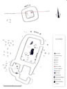
 | Title: Stefánsson map, c.1590 Map-maker: Sigurd Stefánsson Archive or Repository: Manuscript Department, Royal Library, Copenhagen Notes: The map shows Greenland as part of the polar mainland and Helluland, Markland and Skrælingeland south and west of Greenland. Separated from the latter by a narrow strait is a long narrow peninsula called in Latin Promontorium Vinlandiæ, the Promontory of Vinland. The peninsula is more or less on the same latitudes as England and Ireland. Large | Larger |
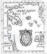
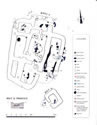
 | Title: Map of northern Europe as envisioned by Adam of Bremen Map-maker: Axel Anton Bjørnbo Pages: 120-224 Notes: Norge - Norway Skridfinner - Saami Riphæiske Mountains - Mountains of the giants Kyklopernes ø - The island of the Cyclops De enbenede - The Unipeds Menneskeæderne - The Cannibals De længelevende - The Long=lived people Hundehovederne - The Doh-headed people Kvindernes land - Land of the Amazons Danmark - Denmark Skåne - Scania [now southern Sweden] Kurland - northern Germany Estland - Estonia Rusland - Russia Large | Larger |
 |

 |
 |
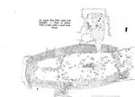
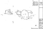
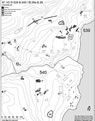
 | Title: Site Grid Map Map-maker: Robin Letellier Archive or Repository: L'Anse aux Meadows Archaeological Excavation Record Reference Number: 2/34 Notes: A grid system covering the entire site was set up by professional surveyors. All individual excavation and photo maps were tied in to this system. The elevations were also mapped. Large | Larger |
 |
 |
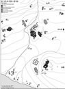
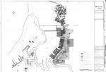 | Title: Parks Canada Excavation Trenches Map-maker: David Brennan Archive or Repository: Parks Canada Archaeology Laboratory, Halifax Notes: Map of some of the Parks Canada excavation trenches. There were additional excavations on the south shore of the bay and east and north of the buildings as well as test trenches through large portions of the site. Large | Larger |
 |
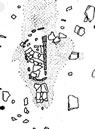
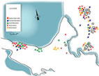 | Title: Aboriginal Occupations Map-maker: Vis-à-Vis Graphics Notes: Most of the Aboriginal sites were on the southern shore of the bay. There were also Aboriginal fireplaces and hut floors around and mixed in with the Norse houses. The Norse upset century-long soil accumulations when they dug their floors into the ground to the same level as that used by Aboriginal people long before them. Large | Larger |
 |
 |
 |
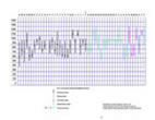
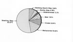 | Title: Slag Chart Map-maker: Birgitta Wallace and John Gaspereau Archive or Repository: Parks Canada Archaeology Laboratory, Halifax Notes: Both iron making and smithing produce slag as byproducts. Metallurgical analyses can determine the origin of the slag. The large pie chart of the L'Anse aux Meadows slag shows that only 4.78% of the slag was from smithing. Except from the smithing hearth slag and some which could not be determined, the rest of the slag was from the iron making. Bear, cinder, and refractories are all associated with the fabrication of iron. Smithing hearth slag is the slag formed during the first hammering of the iron when it is very hot as it is removed from the furnace. Large | Larger |
 | Title: Hall F, Northern Wall Map-maker: Field drawing by Charles Lindsay, finish drawing by John Gaspereau Archive or Repository: Parks Canada Archaeology collection, Halifax Notes: Northern wall of hall F, room IV. The heavy dark lines are the sturdy sedge peat sods forming the northern corners in the room The walls are on top of an old beach bank against which gravel, sand, and stones have accumulated in bands. The dark line following the contours of the bank is dead vegetation from 3000 to 4000 years ago. Before the time of the Norse someone dug a pit in the terrace and threw the sand from it out over the terrace. The Norse filled the pit with strips of sod. Large | Larger |
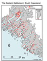
 | Title: Map of Central Part of the Eastern Settlement, Greenland Map-maker: Ole Guldager Notes: Map of the area around Brattahlid. The names are the current Greenlandic Inuit names. Tunulliarfik Fjord - Erik's Fjord Qassiarsuk - site believed to be Erik the Red's Brattahlid Quinngua - also proposed to be Brattahlid Igaliku - Gardar, home of Freydis Erik's daughter, later the seat of the Bishop of Greenland Large | Larger |
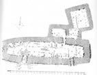
 | Title: Map of Norse ruins at Quassiarsuk, presumed to be Brattahlid Map-maker: Ole Guldager Pages: 78 Reference Number: Fig 99 Notes: General plan of Ruin group 539 & 540 / Ø 29a & Ø 29. 539: 1. Church and church dike, mainly built of large stones. The church measures app. 15 x 7.5 m and the dike app. 24 x 28 m. 2. Dwelling and hall, app. 48 x 9-15 m. 3. Stone-built house, app. 12 x 4 m. 4. Turf- and stone-built house, app. 14 x 7 m. Indistinct and probably part of an early settlement phase. 5. A large byre complex, app. 52 x 8-12 m. 6. A small ruin of indefinite shape. 7. Stone-built house, or stable, app. 16 x 5 m. 8. A large pen, app. 28 x 9-18 m. 9. Stone-built house, app. 12 x 4 m, with an Inuit grave inside. 10-11. Small stable and pen, built on both sides of the in-field dike. 12. A stable? App. 14 x 5 m. 13. Stone-built house, app. 6 x 4 m. 14. Stable or byre? Built of turf and stones, app. 15 x 6 m. The ruin has earlier been excavated and shows standing stall stones. 15. Stone-built house, app. 6 x 4 m. 16. A pen. 17. A large pen, situated some distance from the other ruins, app. 50 x 30 m. This pen may belong to the so-called 'hill farm', Ruin group 538. 59. A small, mainly turf-built church, app. 5 x 5 m, with surrounding churchyard. 60. A very indistinct turf-built house with curved walls, app. 20 x 8 m, perhaps an early dwelling. 61. In-field dike. 540: 18. Dwelling, app. 22 x 12 m. 19. Byre, built of turf and stones, app. 26 x 7 m, with thick turf walls. The ruin has been excavated and shows standing stall stones. 20. A stable? Small turf- and stone-built structure, app. 10 x 4 m. 21. Indistinct turf-built stable. 22. A house, built of large stones. 23. Oval pits. 24. A ruin, app. 11 x 3 m. Ruins 22-24 could not be located in 2000, and have probably been destroyed by modern activities. 25. Stone- and turf-built stable, app. 15 x 5 m. 26. Stone-built house, app. 8 x 4m. 27. A large pen, built of large blocks. 28. A large pen, app. 40 x 30 m. a. Remains of Inuit winter houses.[…] Large | Larger |
 | Title: Map of Norse Ruins at Qinngua that may be Brattahild Map-maker: Ole Guldager Pages: 43 Reference Number: Fig. 42 Notes: Fig. 42. General plan of Ruin group 520 / Ø 39. 1. Stone-built house, 8 x 6 m. 2. Small and indistinct stone-built house (observed by Albrethsen in 1970). 3. Byre, built of turf and stones, 15 x 7-9 m. 4. Dwelling, app. 25 x 10-20 m. 5. A stable, built of stones and turf, 13 x 4m. 6. Stone-built pen, 12 x 9 m, with an extension. 7. A stone foundation of a small house, 4 x 3 m. 8. Byre, built of turf and stones 33 x 8 m. 9. House or stable, built of turf and stones, 8 x 5 m. 10. Part of Ruin 8. 11. Stone-built house, 8 x 5 m. 12. A stable, mainly built of stones, 17 x 5 m. l3.A stone- built pen, 11 x 7 m with an attached enclosure. 14. Stable, built of turf and stone, 17 x 5 m, indistinct (observed by Albrethsen in 1970). 15. Turf- and stone-built complex, probably a dwelling, app. 24 x 14 m. The ruin has recently been disturbed by placing large boulders on top of it. 16. Stable, built of turn and stones, 15 x 5 m. 17. Turf- and stone-built complex, probably a dwelling, 30 x 13 m. 18. An indistinct ruin, built of turf and stones, 6 x 4 m (observed by Albrethsen 1970). It probably lies next to Ruin 17, on the eastern side. 19. Dwelling, app. 38 x 20-25 m. 20. Byre, built of turf and stones, 30 x 9-16 m. At the north-west end, a stone-built dike is seen. 21. Presumed church with surrounding church dike. The central structure (church) has collapsed into a pile of stones, but it probably represents a stone-built house or a stone foundation of about 10 x 6 m. The dike is stone-built and almost square in plan, with a side length of app. 20 m. 22. Dwelling, app. 40 x 20 m, but partly disturbed by recent building activity. In the eastern end, a very distinct stone-built room is seen, measuring 13 x 8 m. lt could be the hall of the church farm. 23. Byre, built of turf and stones, 25 x 12 m. 24. A stable? Built of turn and stone, app. 14 x 7 m, with an extension, measuring 7 x 4 m. On the northern side lies a stone-built pen, measuring 7 x 7 m. 25. Stone-built house, 7 x 4 m. lt is situated on a hill, some distance from the other ruins. 26. Stone- built stable, 17 x 8 m situated some distance from the other ruins, near the next stream (observed by Albrethsen 1970). 27. A stable? An indistinct and mainly turf-built structure, app. 15 x 6 m. This ruin could be an early dwelling. 28. A stable, built of turn and stones, 12 x 3 m. 29. Stone- and turf-built pen, 13 x 8 m, indistinct. Parts of it have been eroded by the river. 30. Small pit house, built of turn and stones, 5 x 3 m. 31. Some remains of stone-built dikes. 32. Turf- and stone-built house, 7 x 4 m. 33. Turf- and stone-built house. Only about half of it (3 x 3 m) remains, the rest has eroded away. 34. A house, built of turf and stones, 7 x 4 m. lt is situated among the later Inuit settlement (a). The ruin could however belong to this phase too, even though it looks slightly different. a. Inuit tent foundations. Earlier surveys by Bruun (1895, 307) and Albrethsen & Berglund 1970-71 (report in the National Museum of Denmark, Danish Middle Ages and Renaissance). Large | Larger |
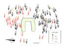 | Title: The cemetery around Thjodhild's church Map-maker: Vis-à-Vis Graphics after K. Krogh Notes: The cemetery around the church that may have been built by Erik the Red's wife Thjodhild. The burials are Christian burials and date from around the year 1000. Leif Eriksson and other members of his family may have been interred here. Vis-à-Vis Graphics after Krogh, Knud J., 1967, pg 94, Viking Greenland. Copenhagen: The National Museum. Large | Larger |
 |
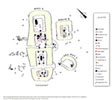 | Title: A-B-C Complex Map Map-maker: Vis-à-Vis Graphics Notes: A-B-C BUILDING COMPLEX The southermost complex consisted of three buildings: hall A, house, house B, and hut C. Hall A The hall was very large, 29 m long on the outside and with more than 1000 square feet of room inside. This is double the size Erik the Red's hall in Iceland. The hall had three rooms, in which people lived, slept and ate, rooms I, II, and IV. All these rooms had a substantial fireplace. The smallest room, II, was probably for one of two leaders on the site and his closest companions. People slept and sat on wooden platforms along the walls. Room III was a workshop where iron was forged into objects, probably boat nails. The iron made in the furnace across the brook was heated over a hot charcoal fire in a pit, then worked on an anvil set into a tree trunk close to the fire. A cloak pin of bronze was found in the firepit. House B House B had a wooden platform along one wall. Iron workers lived here, and bog ore had been roasted on the floor. The fireplace was by the southern wall. The wall was protected by an upright stone. Huts C Hut C was the most primitive dwelling on the site, with no special arrangements for seating or sleeping. People must have slept on straw directly on the floor. It has the same kind of fireplace as in House B. Large | Larger |
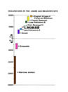 | Title: Timeline Map-maker: John Gaspereau Archive or Repository: Parks Canada Archaeology Laboratory, Halifax Notes: The Norse were alone on the site in the 11th century, but people had camped on the site for nearly 4000 years before them and continued to do so after them. The French had a seasonal shore station on Beak Point from the 18th century or earlier, lasting until 1904. The modern village of L'Anse aux Meadows was established in the 1830s. Large | Larger |
 |
 | Title: D-E Complex Plan Map-maker: Vis-à-Vis Graphics Notes: Hall D Hall D had only one living room, III. It had the usual wooden platforms along the side walls and perhaps along the southern wall. A longfire was in the middle of the floor. Burnt bones were found here. The only one that could be identified was the vertebra of a large cod. At the edge of the fireplace was a small ember box of slate. A broken bone needle was found in the fireplace. Masses of carpentry waste outside the door of room II indicates the presence of carpenters. They may have lived or worked in this room. Room I had no features or cultural deposits, a typical storage room. Whatever was stored here left no traces so it must have been dry goods, or something stored in containers or hanging on the walls. The total floor space in hall D was about 88 square m or 950 square feet. Modest by L’Anse aux Meadows standards, it was still much bigger than Erik the Red’s hall in Iceland. Unlike the two other halls on the site, it had no private sleeping quarters. Hut E Hut E was a small square hut with a stone oven in the northeast corner. The location of the door could not be determined. The oven was a box made of slate slabs. Nineteen 19 fist-sized stones in the northwest corner may have been weights, either for a fish net or a loom. In Iceland, women lived and worked in huts like these. Large | Larger |
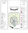
 | Title: F-G Complex Plan Map-maker: Vis-à-Vis Graphics Notes: Hall F Hall F was the largest building on the site, with a floor space of 1728 square feet. It had six rooms with a lean-to shed. There were three living rooms in a row I, II, and III, all with fireplaces. Room I was small and private. This is where the leader of the settlement resided. Rooms II and III were classical skálar {singular: skáli] with platforms along the side walls and a longfire between them. Room IV was a kitchen. A large stone oven in the form of a double slate box covered with a mound of small stones stood in the southwestern corner. It had collapsed so the stones were strewn all over the firebox. Room V was a large storage room. A large deep pit in the northeastern corner contained charcoal and a few burnt bones. It had either a big wooden vat that had burnt, or a cooking pit. Room VII was discovered later than the other rooms, and it is not known where its door was. It was also for storage. Room VI was a shed, open to the south. Post moulds in an uneven line and the imprint of a log are from a frame supporting a boat being repaired. The shed is almost 9 m long. What kind of boat do you think was repaired here? A pit in the middle of the floor and through the eastern wall is modern. The soil from the pit and objects in it were dumped outside so that they ended up outside the building. Hut G Hut G was a small hut set into a slope. It had a fireplace by its southeastern wall. The profile shows that after its abandonment by the Norse, it had been used by later people. Large | Larger |
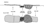
 | Title: Charcol Kiln Diagram Map-maker: Vis-à-Vi Graphics Notes: Profile through charcoal kiln. The kiln was simply a pit in which wood was left smouldering until it turned into charcoal. The charcoal was used as fuel in the iron smelting furnace as it burns at higher temperatures than wood. Large | Larger |
 |